An Anthropomorphic Route Through the City of Houston
1987 —Michael Galbreth
Excepting this block of text, all content on this page is the work of artist Michael Galbreth, taken from The Human Tour original maps distributed in 1987.
Click here for additional context and history on the artist’s website.
Click here for updated hiking, biking, and driving directions.
The Human Tour is a a permanent project designed for Houston and is dedicated to a more human city.
The Human Tour is a permanent project designed for Houston and is dedicated to a more human city.
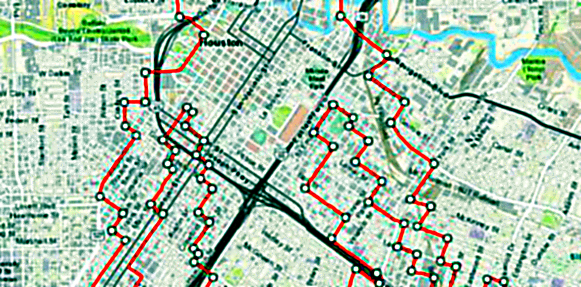
The Human Tour was first conceived in 1982 as an exploration about scaled images using computers. The selected image was that of an outlined frontal view of a male figure. Experiments included reducing the image to fractions of its original size and enlarging it to gigantic proportions. These experiments were designed to investigate the limits of the computer’s abilities to plot very large and very small images. Although the computer was able to understand very large coordinated, it was obviously unable to plot such a huge picture because of the small plotter. Several of these “non-plots” were executed in 1982. Later, the original drawing of the figure was superimposed on a map of Houston. The contours of the figure were adapted to the streets of Houston so that if a drawing of this size were realized, the participant could actually experience the drawing by driving it. Thus an anthropomorphic “driving drawing”.
The Tour travels through a cross-section of communities in Houston’s inner city including such historic districts as the Fourth Ward and the Near North Side as well as burgeoning neighborhoods such as “Chinatown” and the East End. It became evident that the significance of the project was not merely a formal realization of a large drawing, but rather the opportunity for the participants to experience parts of Houston that may have otherwise been unfamiliar to them., The focus then shifted from the formal to the social aspects of the project, and in turn, the implications and responsibilities this brings with it. It is hoped and anticipated that this simple act of driving through different parts of the city will bring about greater awareness to the challenges facing Houstonians and initiate an educational process that will contribute to the humanization of Houston. This is the reason for and the goal of The Human Tour.
This map and the permanent road markers (places at the extremities of the figure: the head, the hands and the feet) are part of the first realization of The Human Tour. Further plans include painting the entire route in such a way as to be visible from the air. Also planned are events and projects that will address issues such as pollution, over-population, housing, transportation, communication, and education.
The Human Tour is dedicated to the most idealistic scenario, a utopian view that sees a solution to each of these problems. When this occurs, communication (from the Latin “a shared space”) will replace transportation. And on that day all of the streets of Houston will be closed except for those of The Human Tour which will be left as a testament that Houston has become the Human City.
Have a safe trip!
—Michael Galbreth, 1987
About the Tour:
The Human Tour is arranged in a north-south orientation with the head at the north and the feet at the south. The downtown area, and more specifically Diverse Works, lie approximately at the heart with the entire figure located inside the “loop”. Certain sections of the route did not easily adapt to the contours of the original drawing which accounts for the rather abstracted image. The Tour is approximately 34.5 miles in length (the perimeter of the figure). The time it takes to complete the Tour is anywhere form 3 to 6 hours depending on such variables as transportation means, driving/biking speed, stoplights encountered, and other miscellaneous delays such as trains, pedestrians, vehicular failure, etc.
Statistics
- Size of the figure (height – head to toe or north to south) – 6.16 miles, approximately
- Distance from head to right hand – 4.8 miles
- Distance from right hand to right foot – 8 miles
- Distance from right foot to left foot – 7.4 miles
- Distance from left foot to left hand – 8.8 miles
- Distance foot left hand to head – 5.5 miles
- The scale of The Human Tour is 67,478.4 times the size of the original computer drawing
These statistics were originally compiled in 1982 and updated in 1986. Individual tourist’s mileage may vary.
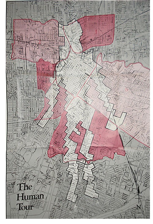
Neighborhood Histories
The following neighborhood histories were excerpted from a report to grant aid to inner city communities. The neighborhoods, whose boundaries are outlined on the map, are noteworthy for their historical significance. (Source: “Housing and Community Development Act, City of Houston, Department of Planning and Development 1975–84”)
1 Near North Side
Many of the factors that account for the character of the Near North Side today have their basis in past history. As its proximity to the Central Business District would suggest, the Near North Side is one of Houston’s oldest settlements. The section of the neighborhood situated west of North Main was annexed in 1839, and the rest of the neighborhood was annexed in 1840, three years and four years, respectively, after the city was founded.
By 1879, settlement had taken place and the area boasted a relatively substantial population. The area, at the time, had an almost even racial distribution of Blacks and Anglos. Blacks resided mostly in the eastern segment of the neighborhood and Anglos in the west.
In the late 1880’s when the Southern Pacific Railroad, once the city’s largest employer and taxpayer, located its maintenance repair shops in the neighborhood, the pace of development accelerated. Industries related to the railroad followed, and the Near North Side soon became a major warehousing center. In addition, industries once crucial to the city’s economy, such as the cotton compression industry, played a major part in the commerce of the neighborhood in those early days.
Although substantial residential settlement had taken place in the neighborhood prior to this time period, the relocation of the Southern Pacific shops was a milestone in the development of the neighborhood. The move precipitated a building boom in the neighborhood and stimulated residential as well as industrial development as builders hurried to meet the increased housing demand brought about by relocation. This historical factor accounts, in large measure, for the present day admixture of land uses in the neighborhood.
In 1891, soon after the construction boom began, the neighborhood experienced a setback when a devastating fire, starting at a lumber mill, destroyed 20 acres of development. In spite of this, however, the neighborhood grew and thrived and by the 1930’s could boast a host of neighborhood facilities and amenities. Included among these were a fire station, a park (Hennessey Park), a theater (North Side Theatre), and elementary school (Lee Elementary), a high school (North Side Junior High), a library (Carnegie Library), and a hospital (Southern Pacific Hospital).
As happened in many other large cities, the neighborhood began to undergo a transition after World War II, when the racial composition of the Near North Side altered as large numbers of Anglos left the neighborhood for the suburbs. They were replaced, for the most part, by Mexican-Americans. This accounts for the present ethnic diversity of the neighborhood.
2 First and Sixth Wards
The First and Sixth Wards is one of Houston’s oldest neighborhoods. Land was plotted between the 1850’s and 1890’s. The key to growth in the First and Sixth Wards was the development of the Texas Central Railroad. This transportation artery brought residents, business, and industry to the area.
The First and Sixth Wards was first inhabited by German settlers, followed by eastern and southern European immigrants in the 1880’s. During the 1900’s, blacks and Hispanics moved into the area, as whited dispersed to the outlying neighborhoods of Houston. The area was annexed by the City in 1839.
The Sixth Ward is separated on the north from the First Ward by the Southern Pacific Railroad tracks. The Old Sixth Ward Historic District, also called the Sabine, features a number of restored homes and was placed on the National Register of Historic Places in 1978.
(The First and Sixth Wards are also known as Washington. The following is the history of Washington. — Michael Galbreth)
Washington contains some of the oldest communities in the city of Houston. Baker’s addition, also called the Sabine area, was developed in the late 1830’s and 1840’s, shortly after the founding of Houston in 1836. The sections east of Brashear Street were annexed by Houston in 1839 and 1874. Until the abolition of the ward system in 1905, these sections were designated as the First and Sixth Wards.
The development of Houston’s railroads traversing WAshingron directed frowth to the neighborhood. By 1903, the area east of Wiehman was annexed and by 1913, the remainder of Washington was part of the city of Houston. In those early years, the population was predominantly employed by the railroads and railroad related industries, suc as the Dickson Car Wheel Company, previously on the site of the Blue Ribbon Rice Company.
The railroads and the early major streets, such as Houston and Washington Avenues, influenced industrial location in the area, as did later improvements such as the Waugh Drive bridge over Buffalo Bayou and the completion of Memorial Drive. The Studemont-Montrose bridge over the bayou and the Katy Freeway are the latest major improvements, both completed in the late 1960’s.
3 Fourth Ward
The Fourth Ward has its origins steeped in the very beginnings of Houston. The land was first held by Obedience Smith, an original settler who bought up most of what is now southwest Houston in he 1830’s. The Smiths gradually sold some of the land to wealthy families for use as truck gardens.
San Felipe Road (now West Dallas Street) was the western road out of town to the Brazos River plantations and Austin in the 1850’s. The road was lined with trees, small truck farms, and the burial grounds (now Founder’s Memorial Cemetary) in which Houston’s earliest settlers are buried. On the Corner of West Dallas and Valentine, at the entrance of the cemetary, stood the Hanging Tree, used by local law enforcement. The victims lie in unmarked graves within the cemetary walls. In back of the Founder’s Memorial Cemetary is the oldest Jewish graveyard in Houston.
After the Civil War, several families sold of gave their truck gardens to freed slaves. The new settlers subdivided the property into the site of Freedmanstown, which lay where Allen Parkway Village now stands. Over 25 small square blocks bounded with streets with names like Howard, Chambers, Center, and High, no longer exist on the city’s maps. Negroes from outlying camps along the Brazos River moved to Houston, so that by the turn of the century, one-third of Houston’s population was black.
Until the middle of the 1880’s, Negroes owned most of the land in the Fourth Ward. Then much of the land was bough and subdivided by W. R. Baker, mayor of Houston at the time. The portion of the ward not annexed in 1830 was annexed in 1874.
Conditions in the ward continually worsened due to overcrowding, a factor in Houston’s largest race riot in August, 1917. Federal troops , mostly blacks , stationed at camp Logan, were awaiting orders during World War I. Angered by segregation in public places, soldiers scuffled with police and were soon rioting. Peace was restored after ten days.
In the 1920’s and 1930’s, the Fourth Ward was an active, teeming community. The center of the ward was the old Pilgrim Hall at Heiner and West Dallas (razed during freeway construction). The block square structure, operated by the Progressive Orger of Pligrims, housed officed for doctors, lawyers, and the Forward Times newspaper, as well as ballrooms, club rooms, and a hall where jazz greats came to play on Saturday nights. There was a roller scating rink on the roof of the structure.
The great difference from these earlier times is that much of the land is no longer lived on dus to uses whach have replaces of removed the homes. Jeff Davis Hospital was opened in the mid-twenties and San Felipe Courts (now Allen Parkway Villaige) was build in 1939 , initially for whites only .
After World War II, however, the trend was boosted by integration and the momement of Blacks to newer areas. The first moves were toward Texas Southern University, then to Studewood, Southpark, and Riverside Terrace. Kashmere Hardens and Acres Homes were settled by people moving our from the Fourth Ward and Lions Avenue.
Further development and demolition has caused further reduction of the Fourth Ward population. The construction of the Gulf Freeway was the major change which split the old ward, relegating the eastern portion to the central business district, where it has been razed as part of the Allen Center project.
Further population losses have occurred in the ward due to clearing for the city garage and the construction of Lincoln High School. Furthermore, the program of demolishing dangerous buildings is causing an ever increasing proportion of vacant parcels.
In the portion of the ward to the south of Gray, some commercial and service firms have moved in, displacing residents. The area, however, is being influenced by Montrose/Westheimer where rehabilitation and construction activity is common.
4 Midtown
The initial growth of Midtown occurred between 1873 and 1912. In 1873, the southern limits of development were at Hadley Street. By 1912, the city had expanded southward to Wheeler Street. At the turn of the century, the South Main area was one of the most fashionable residential neighborhoods in the city. Other fashionable residences lined Crawford, Caroline, and other nearby streets. Most of these residences have now been subdivided into apartments, converted to commercial uses, or demolished to make way for new construction. Some of the remaining structures are the John Henry Kirby house (1928), 2006 Smith; the Edward H. Sewall house (1912), 3412 Austin; and the house at 2225 LaBranch.
Midtown, due to its location adjacent to the central business district and its high level of accessibility, has become part of the downtown frame area, serving a highly specialized function within the structure of the city. Unlike the central business district core, the frame is not an easily delineated or widely recognized section of the city. Its boundaries are seldom sharply defined. In fact, it has usually been considered a zone of transition. The frame, however, has a land intensity second only to the core and a use pattern in which the wholesaling, auto sales and service, transportation terminals, and institutional uses are important elements. The frame differs from the core in that many frame area firms tend to serve other firms rather than serving retail customers; the firms often have larger space requirements and lower rent-paying ability than core firms; extensive areas of off-street parking are common; building heights are geared to walk-up; and residential uses are present. Frame areas tend to expand into areas of dilapidated housing on their fringes.
5 Third Ward
(In the community development reports by the City Planning Department from which these brief histories were obtained, there was no historical reference made about the Third Ward. Nevertheless, I felt that it was important to include it on the Tour as it is one of the older communities of Houston and part of the “Ward” division of neighborhoods which dates back to the late 19th century. It may be of interest to note that two major universities lie within the Third Ward’s boundaries; Texas Southern University and the University of Houston —Michael Galbreth)
6 Navigation
One of Houston’s oldest neighborhoods, Navigation began developing during the late 1800’s. In 1870, the moving of the former Buffalo Bayou, Brazos, and Colorado Railroad to this section of Houston, from Harrisburg, stimulated development of the area. About the same time, the Southern Pacific Railroad also located its shop in the area. The coming in the 1880’s of the electric street car and a new road to Harrisburg encouraged further development.
After 1910, Navigation was known as the city’s major Mexican-American area, El Segundo Barrio. In 1911, Our Lady of Guadalupe Church qas formed as the first church for Mexican-Americans.
Annexation of this community began in 1840, in the northwest section and proceeded piecemeal to the southeast. The process was completed in 1927 when the southeast corner of the area was annexed. Recent major changes to the area have been the construction of the Gulf Freeway in 1948 and the Eastex Freeway in 1966.
Directions
L indicates a left turn
R indicates a right turn
Begin at the top of the column and read down.
Starting at the corner of Everett and Morris (the top of the head), proceed west on Morris toward N. Main, then:
L N. Main
R Morris
L Thomas
R Quitman
L Houston
L Shearn St
R Holly
R Dart St
L Houston
proceed to I-45 South, exit Dallas Ave.
(Bike Detour: from Houston, exit Memorial, L Rusk, R Bagby)
R Dallas
L Crosby
R Cleveland
L Valentine
L Webster
R Bagby
L Westheimer (Elgin)
R Milam
L Holman
R Main
L Wichita
➤ When you reach the corner of Wichita and Austin, stop. You are now at the Right Hand.
Look for the marker on the northwest corner of the intersection.
L Austin
L Alabama
R San Jacinto
L Tuam
R Main
L Hadley
R Travis
L Gray
R Louisiana
R Leeland
R Milam
L Jefferson
R Fannin
L Pierce
R Caroline
L Webster
R La Branch
L McGowan
R Jackson
L Aniti
R Chenevert
L Elgin
R St. Emmanuel
L Holman
R Hutchins
L Berry
R Bastrop
L Winbern
R Dowling
L Cleburne
R Live Oak
L Rosewood
R Delano
L Rosedale
R Ennis
L Prospect
L Palmer
R Southmore
R Sampson
R McGrefor
L Ardmore
L S. McGregor
R Del Rio
L Tampa
R Culberson
L Dixie
R Tierwester
L Alice
➤ When you reach the corner of Alice and Scott, stop. You are now at the Right Foot.
Look for the marker on the southwest corner of the intersection.
L Scott
L Yellowstone
R LaSallette
L Griggs
R Swank
L Rio Vista
R S. McGregor
L Scott
L N. McGregor
R Tierwester
L Oakdale
R Burkette
L Blodgett
R Ennis
R Cleburne
L Caney
L Truxillo
R Briley
L Alabama
R Ennis
R Elgin
R Velasco
L Holman
R Tierwester
L Southmore
R Scott
L Griggs
R Scottcrest
L Porter
R St. Augustine
L Hull
L Cullen
R Hull
➤ When you reach the corner of Hull and Paris, stop. You are now at the Left Foot.
Look for the marker on the northwest corner of the intersection.
L Paris
L Cosby
R Cullen
L Perry
R Foster
L Porter
R Sidney
R Dixis
L Goforth
L Griggs
R England
R Fernwood
L Oakcrest
L S. McGregor
R Scott
R N. McGregor
L Honeycircle
L Wichita
R Scott
L Alabama
R Napolean
L Holman
R Sampson
R Gulf Freeway “feeder road”, south
L Scott
L Gulf Freewal “feeder road”, north
R Ennis
L Leeland
R Dowling
L McKinney
R St. Emmanual
R Texas
R Dowling
L Capitol
R Nagle
L McKinney
R Palmer
L Polk
R Edmundson
L Leeland
R Hussion
L Coyle
R Cullen
L Elgin
➤ Continue under I-45 to Lockwood. When you reach the corner of Lockwood and Munger, stop. You are now at the Left Hand.
Look for the marker no the northeast corner of the intersection.
L Leeland
L Ernestine
R Harby
R Sidney
L Leeland
R Cullen
L Polk
R Milby
L McKinney
R York
L Harrisburg
R Delano
L Commerce
R Bastrop
R Navigation
L Runnels
R McKee
L Nance
L McKee
R Nance
L William
R Sterret
L Walnut
R Wood
R N. Main
R Brooks
L Everett
R Harrington
L Chestnut
R Pinkney
L Gentry
L Henry
R Chestnut
L Quitman
R Everett
➤ When you reach the corner of Everett and Morris, stop. You have completed “The Human Tour”.
Look for the marker on the southwest corner of the intersection.
Credits
National Endowment for the Arts
Rockefeller Foundation
Texas Commission on the Arts
The Enron Corporation
Colorado Video, Inc.
The Southwell Co.
Approved by I.C.E.
The City of Houston
The Houston Public Library
Diverse Works, Inc.
The Southwest Alternate Media Project
The Houston Festival Foundation, Inc.
The Houston Municipal Arts Commission
Special thanks to Diverse Works, Inc.

